Federico Garcia Lorca Granada Jaen Airport (GRX)
City Orientation and Maps
(Granada, Spain)
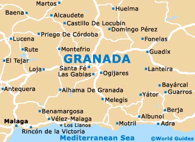
The historic city of Granada lies on the southern side of Spain and is close to the coastline, which can be reached in less than 40 minutes. Granada is situated around 160 km / 100 miles to the east of Seville. Other areas of interest nearby Granada include Jaén, Los Villares, Alcalá La Real, Iznalloz and Albolote to the north, while the Alhama de Granada and Malaga lie to the south-west.
Also nearby, Antequera and Santa Fe can be found to the west of central Granada, close to Granada Airport (GRX), with the Sierra Nevada National Park (Parque National de Sierra Nevada) to the east. Here you will find spectacular mountainous scenery and a number of seasonal ski resorts, together with a range of recreational activities, such as horseback riding, and both walking and cycle trails.
Granada Airport (GRX) Maps: Important City Districts
The centre of Granada is very much based around two main streets, the Calle Reyes Católicos and the Gran Via Colón, both of which meet up at the Plaza Isabel La Católica. At this point, the Calle Reyes Católicos heads in a south-westerly direction, towards the Puerta Real area, also north-east, where it reaches the Plaza Nueva.
Granada's Cuesta de Gomérez runs in a north-easterly direction towards the city's famous Alhambra fortress, which is known for its Muslim heritage and stunning hilltop views. Nearby, the El Albaicin district (Albayzin) contains a number of ancient buildings dating back to the 16th century, together with a good selection of Tapas bars and public squares. Other areas of interest include the relaxed and lively Realjo district, and the Sacromonte area, offering a strong gypsy flavour and plenty of Flamenco dancing.
Spain Map

Granada Map